INTRODUCTION
This Non-Technical Summary (NTS) provides a general overview of the findings of the
Environmental Impact Assessment (EIA), as reported in the Environmental Statement
(ES), which has been produced for the Shotton Paper Mill scheme, referred to within this
document as the ‘proposed development’. The EIA considers the proposed development
as a whole and the ES has been produced to support and inform the three planning
applications for the Site.
The EIA and this NTS has been prepared by SLR Consulting Ltd.
THE APPLICANT
The Applicant is Shotton Mill Ltd, part of the Eren Group.
THE PROPOSED DEVELOPMENT
The proposed development is for the re-development
and expansion of the Shotton Paper Mill which
was bought by Eren Group in September 2021. The
proposed development, which the ES supports, is
the subject of three separate planning applications as
follows:
• Main Site & Expansion Land – the Main Site
comprises the redevelopment of the existing
site operations for card and containerboard
production and covers an area of approximately
61 hectares (ha). The Expansion Land covers to
22ha. It lies to the north of the Main Site and is
currently vacant, having previously formed part of
Shotton steelworks which was demolished in the
1980s. It would be developed for tissue paper and
products.
• Combined Heat & Power (CHP) Facility – the
CHP Facility falls within the Main Site, but is the
subject of a separate planning application to
be determined by Welsh Government due to it
falling under the definition of a ‘Development
of National Significance’ (DNS). The CHP Facility
would provide approximately 60Megawatts of
power (MWe) to the Site, which in combination
with existing onsite energy generation would
make the Site self-sufficient in energy.
• Piling – advance accommodation works (piling)
are required in the central area of the Site.
The total area that these three applications cover is
83 ha in size. The proposed development is described
further within the Project Description section of this
document.
THE SITE AND SURROUNDING AREA
The Site
The proposed development is located within the Deeside Industrial Park at Weighbridge Road, Deeside, Flintshire CH5 2LL at National Grid Reference (NGR) SJ30407159 (the Site). The immediately surrounding area is predominantly industrial with Tata Steel adjacent to the Site’s southern boundary and the remainder of Deeside Industrial Park lying immediately to the east. The figure below shows the proposed development within its geographical setting.
The Main Site comprises both buildings that will be demolished to make room for the new card and containerboard production processes, and a number of existing industrial and manufacturing units which will be retained as an integral part of the proposed development. The figure below focuses on the Main Site and shows buildings to be retained in pink, and new buildings in blue.
Within the southern area of the Site is a series of lagoons, used for the treatment of process water. The final lagoons can be seen in the photograph below.
The northern area of the Site, the Expansion Land, is a revegetated area which is bordered by the existing A548 Weighbridge Road to the north and local estate road to the south.
A view of the Site looking north east from the final lagoons can be seen in the photograph below.
Site
Lying to the north and north west of the Site is the Dee Estuary which is subject to a number of ecological designations.
North of the Site
Looking north from the Site, the surrounding area is dominated by the Dee Estuary with a series of mudflats and grassland areas. The Dee Estuary is designated as a Ramsar Site, Special Areas of Conservation (SPA) and Special Protection Area (SPA).
There are a number of small villages to the north and east of the Site, in the Wirral (England). These include Burton which is 2.5km north of the Site and Puddington 3km north east of the Site.
South of the Site
The Tata Steel lies to the south of the proposed development. The lagoons within the Tata Steel land ownership have become an important site for nesting common tern (Sterna hirundo) and are separately designated as Shotton Lagoons and Reedbeds SSSI.
PROJECT DESCRIPTION
The UK is currently a net importer of both containerboard products and tissue products, while at the same time being a net exporter of recycled (waste) paper. The proposed development is intended to close both these gaps by switching from the former production of newsprint (a declining market) to make card, containerboard, tissue paper and tissue products. Increased levels of production when compared with the former newsprint production will allow the use of more recycled paper, card and other fibres, with the proposed new cardboard paper production facility using 100% recycled materials.
The Applicant has been looking for a suitable Site in the UK for some time to expand its paper and packaging division. Having acquired the established paper production site at Shotton Mill, significant capital investment is required to change the type of paper produced and bring the building and plant up to modern sustainable standards.
The proposed development has a number of functions. The Main Site will involve the redevelopment of the existing operational site. Within this area some of the existing buildings
will be retained such as the reception area, recycled paper storage buildings, the Materials Recovery facility, and the Biomass Plant and wood preparation plant.
There will also be a need to construct new buildings, which would house the Cardboard Paper Machine and the Corrugating Machine, Warehouse Building, Dispatch Area, Effluent Treatment facility, and ancillary buildings including Starch Process and Storage Building, Raw Materials Storage Area and power services area.
The Expansion Land would house the new Tissue Paper Mills and associated Buildings including Reel Storage, Converting Building and Finished Goods Building. The figure below shows the expansion site as well as the main Site and the new combined heat and power (CHP) plant which is discussed further below.
The CHP Facility will provide an additional 60MWe power to Shotton Mill. The proposed CHP facility would have an efficiency of around 80% due to the utilisation of the heat that is a by-product of the electricity generation process. It is therefore considered a low carbon source of energy.
ALTERNATIVES CONSIDERED
The regulations which require an Environmental Impact Assessment, discussed below in the Scoping and EIA Methodology, require the Environmental Statement to consider reasonable alternatives studied by the applicant, and an indication of the main reasons for the options chosen.
SLR has worked with the Applicant as part of a systematic process of site search within England and Wales. Although the Site was not available at the commencement of the site search process, it was incorporated into the search once the former owners announced its sale, and immediately performed well, ranking top of the ‘long list’ of sites under consideration.
The alternatives considered in preparing the scheme design are limited in that the functionality of the design is paramount and must take account of existing buildings and infrastructure being retained. The selection of technology is based on the client’s desire to establish a state-of-the art paper manufacturing facility, with a high level of resource and energy efficiency.

SCOPING AND EIA METHODOLOGY
The requirement for an assessment of the potential environmental effects on the existing environment is a result of the Environmental Impact Assessment Regulations (2017). The regulations require that a scheme which falls under ‘Schedule 1’ will require an Environmental Impact Assessment (EIA). The proposed development falls under this schedule and therefore has been the subject of EIA.
As part of the EIA process a Scoping Request was submitted to each of the determining authorities (Flintshire County Council and PEDW (Planning and Environment Decisions Wales).
SLR prepared a Scoping Report that described the proposed development and outlined the likely significant effects on the existing environment with regard to: landscape and visual receptors, ecology, water environment, noise, land quality, air quality, traffic and transport, socio economics, and cultural heritage. For these technical areas, a methodology for assessing the ability of the existing environment to accommodate the proposed development. In addition to this, consideration was also given to waste, major accidents and disasters.
Following consultation with regulatory bodies a Scoping opinion / Direction was issued by Flintshire County Council and PEDW that provided commentary on the Scoping Report and a direction for the assessment.
The ES has taken into account the feedback received on the Scoping Report. The ES draws together the findings of the EIA using the agreed methodology and is a comprehensive assessment which looks to inform the reader of the potential effect of the proposed development on the environment. It comprises technical assessments which are supported by surveys; appendices and drawings and provides a detailed, systematic and objective assessment. The ES has been produced by experts within their technical field.
The next section of this NTS summarises the findings of the technical assessments which have been undertaken for the proposed development.
LANDSCAPE AND VISUAL IMPACTS
The landscape and visual impacts assessment (LVIA) looks at the potential effects that the proposed development could have on the existing landscape and visual receptors within a specific area. The assessment has been undertaken following the relevant best practice and guidance, which for landscape is the Guidelines for Landscape and Visual Impact Assessment (GLVIA3).
The LVIA has a number of objectives which include looking at the landscape character of the Site and its immediate surroundings to see if there are any notable individual landscape elements which the assessor needs to be aware of. A view on how sensitive the landscape and identification of potential receptors is also established. A further objective is to identify and describe the changes to the landscape and visual amenity that could occur as a result of the proposed development.
Site visits were undertaken by an experienced landscape architect in December 2021 and January 2022. The purpose of the site visits was to understand the study area that would be assessed, to examine the landscape character and to look at the view of the proposed development from a specific area (or viewpoint) to better understand how the proposed development would fit within the landscape.
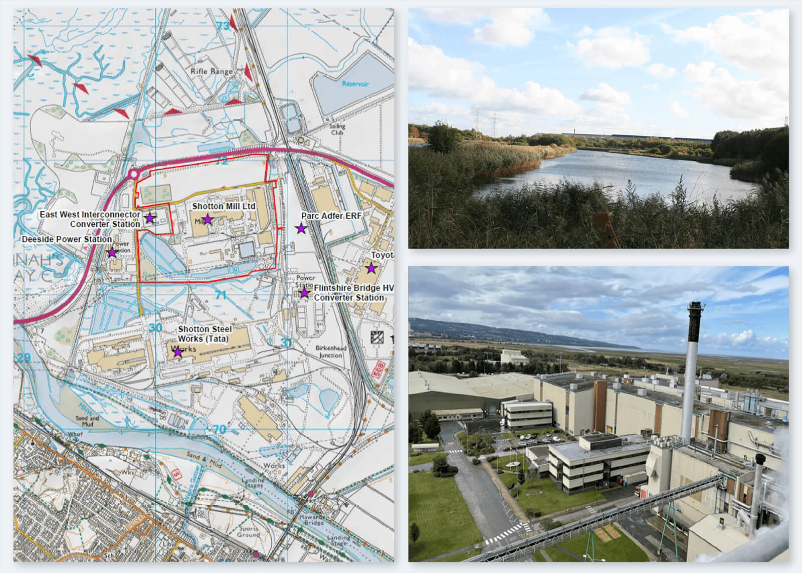
The LVIA found that the landscape in the area is dominated by large scale industrial building and infrastructure which supports these buildings which have developed along the River Dee. There are a number of buildings and structures which play an important part of defining the local landscape character, the largest being Parc Adfer EfW, Deeside Power Station, Tata Steel Works, Shotton Paper Mill, Flintshire Bridge and Connah’s Quay Power Station, along with numerous overhead power lines and their pylons. The proposed development would not have a significant impact upon the landscape that these industrial building sit within.
There are a number of viewpoints which would have a view of the proposed development during operation. However, due to the existing industrial setting the proposed development sits within this industrial setting well and so views to the proposed development would not result in a significant and negative effect on visual amenity. However, one viewpoint (K) which is located on Weighbridge Road, and approximately 100m from the nearest proposed building would have a large change in its view as a result of how close this viewpoint is to the proposed development.
WATER ENVIRONMENT
The water environment chapter assesses the impact of the development on hydrology, hydrogeology and flood risk. The assessment does not consider the flood risk posed to the proposed development itself; however, this is set out in a separate Flood Consequence Assessment (FCA) which is included as a technical appendix.
The Site is located on an area of raised land within the tidal flats associated with the Dee Estuary. Across the A548 dual carriageway is White Sands, which consists of a network of small tidal creeks. A significant channel running across this area in a west to east plane is White Sands Gutter which connects to the Dee Estuary to the north. Discharges of storm water and effluent from the Site are currently, and will be maintained, to this feature.
On the east side of the dual carriageway and continuing north is an embankment that separates White Sands tidal flats from the Site. On the eastern side of the embankment, surface water drains to channels called Fingerpost Gutter and Broken Bank Drain routing them towards the dual carriage roundabout to the northwest of the Site, then along the east side of the A548 as a single watercourse.
Running along Weighbridge Road to the east of the Site is a drainage ditch that connects to a channel to the south of the southern boundary. To the south of the Site is Shotton Lagoon and Reedbeds, a Site of Special Scientific Interest (SSSI), created from the lagoons at Tata steelworks (still operational). During wet periods the channel present to the south of the Site’s southern boundary would connect into the lagoons.
The proposed development design includes a number of incorporated mitigation measures that reduce the risk posed to the water environment and also provide betterment against the previous operational paper mill.
The development would install a new Sustainable Urban Drainage System (SuDS) which would provide water quality and biodiversity benefits and connect into the existing southwest lagoon which will provide attenuation to offset the increases in runoff associated with any additional hardstanding. The details of the SuDS will be agreed with the SuDS Approval Board (SAB) a process that occurs independently to the planning application.
The SuDS would be installed at the start of the construction phase and therefore provide mitigation for any runoff contaminated by spillages or sediment. They would also be inspected and restored if any impacts have occurred during the construction phase to ensure their longevity during the operational phase.
In line with the permit conditions, the discharge to White Sands Gutter will be monitored and switched off should any breaches by identified. There is a large freeboard capacity within the lagoon to accommodate storm flow in the event of pollution occurring. If remediation cannot be achieved onsite, it would be tankered to a suitable facility.
During construction a Construction Environmental Management Plan (CEMP), based on industry best practice, will be implemented to control construction activities and minimise water pollution. This will be agreed with the planning and regulatory authorities. The CEMP will include measures to control the use of chemicals, fuels and oils and cementous materials at the Site so as to prevent them entering the water environment. This will look to minimise the use of any potentially hazardous materials, but where required their use will be planned with storage and transference being restricted to lined and bunded areas. The CEMP will also include measures to minimise the generation of turbid runoff from construction area and prevent sediment being tracked from the Site onto the adjacent road.
Monitoring of local surface water features will also be completed to confirm that no significant impacts are occurring.
When operational, the Site would have a new Effluent Treatment Plant for the treatment of foul and process water. Water from any process areas of the Site will be routed via the treatment works before being discharged into the lagoon system. This follows the same process as the previous paper mill, however the new effluent treatment plant been designed to current best practice and so will improve the water quality of discharges (including a reduction in nutrients) from the Site towards the Dee Estuary when compared to the baseline.
During the operational phase chemicals, fuels and oils would be used only in controlled areas which drain to the Effluent Treatment Plant. Additionally, there will be a vehicle management system and treatment of storm flows provided within the SuDS network for areas not draining to the Effluent Treatment Plant.
As such, with the implementation of the mitigation measures outlined above, no significant residual effects to the water environment, including both the Shotton Lagoon and Reedbeds and the Dee Estuary, are considered likely.
NOISE & VIBRATION
The noise and vibration assessment for the proposed development has looked at what effects the proposed development could have on the surrounding environment during construction and operation. The assessment has been undertaken in accordance with the relevant guidance and standards applicable to noise and vibration.
Sensitive receptors were identified, and these included ecological receptors such as Burton Marsh Farm and residential receptors such as Kenneth Cross Way and Rock Cottages. Noise surveys were undertaken in September 2021 when the existing Shotton Paper Mill was operating in normal conditions and a further noise survey undertaken in October 2021 when the existing Shotton Paper Mill had ceased operation.
The construction operations will require a variety of machinery to be used onsite at varying times. The machinery has different noise levels, and the assessment identifies the type of machinery and construction methods that will likely be required to build the proposed development.
The assessment also looks at the traffic which will be accessing the Site including Heavy Goods Vehicles and cars. All of these elements were then put into a noise model which predicts the noise level changes on sensitive receptors before any mitigation has been designed. Mitigation during construction and mitigation during operation, such as noise fences can be designed into the proposed development if required.
The assessment has shown that specific noise mitigation measures will not be required because during construction there would not be an increase in the noise levels high enough on the sensitive receptors to require mitigation. However, a Construction Environment Management Plan (CEMP) has been produced which is a document used by the construction team which provides information on the Best Practicable Means to reduce noise levels during construction.
When the proposed development is operational the levels of noise including noise generated by site traffic will be small and therefore operational mitigation is not required.
WASTE & RESOURCES
This chapter considers the use of materials within the construction of the proposed development. It also considers the raw material feedstock used in the operation of the new plant. With regard to card production the process would solely utilise recovered paper, card and other materials that are collected for recycling by local authorities and businesses across the UK as its raw material feedstock. The tissue manufacturing process would use a proportion of office (white) paper and wood pulp. The existing Biomass Plant would contribute to the paper mill’s energy requirements through the use of recycled wood and wood products.
The chapter also considers use of water resources, as water is an important element of the paper making process. Paper mills require vast amounts of process water for paper production. Shotton Mill benefits from its own private water supply, which is drawn from a location on the River Dee above Chester and transported by underground pipeline to the Site. There is no limit on abstraction volumes.
Of the total water usage of 1,386 m3/hour, approximately 45% would be recycled, resulting in a significant reduction in water demand. This is substantially higher than the recycling rate of 10% achieved for the newsprint plant. The balance of approximately 55% would be discharged via the existing consented Discharge Point to the River Dee, thereby returning into the same river from which it was extracted.
The proposed development has been designed to optimise the use of recycled materials and minimise waste generated on-site, thereby making a substantial contribution to national and local objectives in moving the management of waste up the ‘waste hierarchy’.
Construction waste management would be undertaken in accordance with the waste hierarchy, and the Site Waste Management Plan in accordance with Welsh legislation.
It is considered that the embedded good practice design principles and mitigation are unlikely to result in significant adverse effects and have the potential to be significantly beneficial.

TRAFFIC AND TRANSPORT
The approach to Traffic and Transport has been discussed with officers at Flintshire County Council as part of the pre application engagement. This included the submission of a Transport Assessment Scoping Report in January 2022.
The proposed development is intended to be constructed over a 4-year period between 2022 and 2026.
Construction traffic would include the movement of workers and construction vehicles associated with the construction of individual buildings and supporting infrastructure. The levels of construction traffic have been quantified based on details reported by the proposed operator and the known construction approach.
The effects of construction traffic will be minimised through the implementation of a Construction Traffic Management Plan (CTMP) which can be regarded as a standard control measure for applications of this scale, and which is expected to be secured by planning condition. Specific measures will be agreed with the highways authority but are anticipated to include the following:
• Phasing of construction;
• Access arrangements for workers and for HGVs;
• Working hours;
• Construction traffic routing which will be confined to major highways. It is anticipated that most construction materials will arrive directly via A548 Weighbridge Road / Shotwick Road and the A494;
• On-site HGV wheel wash facilities will be provided and engine idling whilst stopped will be minimised;
• Traffic management measures; and
• Parking and loading arrangements.
Once operational, traffic flows generated by the proposed development are likely to increase substantially on local highways, but as these routes are not considered sensitive then the overall effect would be negligible with regard to severance, pedestrian delay, pedestrian amenity, driver delay, and safety.
A number of sustainable travel measures will be implemented to ensure the impact of the development is mitigated.
The development will include the construction of a foot/cycleway from the Site entrance on Weighbridge Road to the existing National Cycle Network approximately 1km north east from the site entrance.
This will connect the Site to the wider cycle network and provide good routes from the Site to many nearby towns and cities. Upon delivery of the Deeside Parkway railway station, travel options to the Site will be further diversified.
The current on-site cycle infrastructure will also see improvement, with an increased number of cycle parking spaces to be provided. This could potentially include e-bike charging points for users to recharge their e-bikes in line with demand.
Liftshare as a car-sharing platform will be encouraged amongst members of staff, as the shift work-pattern has good scope to be incorporated into lift share, due to a large number of workers beginning and concluding work at similar times.
The above measures will be incorporated into an Outline Travel Plan that will support the Site, ensuring that members of staff are aware of the travel options available to them.


SOCIO-ECONOMIC
The socio-economic chapter assesses the potential beneficial and adverse effects on the local area, through the impacts on recreational assets, such as long-distance routes, land use and the potential impacts on the local labour market and economy through the proposed developments construction and operational phases.
Desktop research forms the baseline study for the assessment, which comprises two separate parts; the Wider Study Area (WSA) and the Local Area of Impact (LAI). The WSA considers the ‘home’ local authority of the proposed development, Flintshire County Council, and the neighbouring local authority, Cheshire West and Chester Council, where there is an expected to be a considerable draw from the labour market due to the closeness of the proposed development to these areas. The LAI comprises a 2km radius of the proposed development’s boundary, where the impacts on recreational assets are most likely to occur.
The socio-economic assessment is split into two parts; the impact of the proposed development during the construction phase, and impact during the operational phase.
During the construction of the proposed development, the assessment found that the proposed development would generate approximately 400 jobs. This does not include additional jobs which could be created due to the demands put on supply chains and deliveries.
It is estimated that approximately 20% of these jobs may be taken by people from the respective local authorities of WSA and there will be additional employees commuting to the Site and a number of specialised roles. The creation of the new jobs both directly for the Site construction and through the increased demands on the supply change will have a beneficial effect.
There are a number of recreational facilities of national or regional importance, and there of high to medium sensitivity. These include RSPB Burton Mere Wetlands and long-distance walking and cycling routes, including the Wales Coastal Path, the Dee Way and National Cycle Network (NCN) routes. NCN 568 passes the Site boundary but with the implementation of a Construction Environmental Management Plan (CEMP), the NCN route would remain open and safe for users, resulting in a low impact. Overall, with mitigation in place it is unlikely that there will be an adverse residual impact on recreational facilities.
For the operational phase, the proposed development is expected to retain the current 190 roles at the existing paper mill and create an additional 660 new roles, which would result in 850 total roles. As with the construction phase, during operation the proposed development would likely result in additional indirect roles, through supply chain services such as logistics and waste management amongst many others. In addition to this, training and skills development would be offered to new and existing employees to ensure they have the necessary skills and expertise to work effectively with the new technologies and output.
For recreational facilities it is unlikely that there will be an impact upon these during the operation of the proposed development. NCN 568 may experience increased levels of use through the potential for the increased numbers of employees using the route.
Overall, the socio-economic impact of the proposed development is expected to be beneficial.

ECOLOGY AND ORNITHOLOGY
The Ecology and Ornithology chapter of the ES describes the ecological conditions at the Site, including the Main Site and the Expansion Land, as known as ‘Plot A4’. The chapter identifies important ecological features with potential to be affected by the proposed development and values and assesses the impacts upon these receptors according to the approach set out in published good practice (CIEEM, 2018). The ecological assessment assesses the potential impacts of the proposed development upon biodiversity receptors, including designated sites, habitats and protected wildlife, and details appropriate mitigation measures required to avoid, reduce or compensate for these impacts. Any residual impacts are identified and their significance assessed.
Desktop studies and field surveys have been completed by SLR Consulting Ltd in 2021 and 2022. Desk study data has been collected from Cofnod Environmental Records Centre (CERC), RECORD (Local Environmental Records Centre for Cheshire, Halton, Warrington and Wirral), Local Wildlife Site citation records from Cheshire Wildlife Trust, British Trust for Ornithology WeBs and Merseyside ringing group’s bird
data, The Woodland Trusts’ Ancient Tree Inventory and HM Government’s web-based spatial data resources from the Multi-Agency Geographic Information for the Countryside (MAGIC).
Field surveys undertaken at the Site include:
• A habitat survey, following the UK Habitat Survey (UKHab) classification methodology and protected species scoping survey in June 2021 and updated in August 2021.
• Habitat Suitability Index (HSI) and an eDNA sample for Great Crested Newt at a pond located on the boundary of the Plot A4 land.
• Breeding and wintering bird surveys from June 2021 until March 2022, with surveys proposed to conclude in May 2022.
• Aquatic PSYM survey of Lagoon 2b undertaken on 20 January 2022.
• Bat activity transect undertaken on 26 October 2021.
The valued ecological features, their importance and a summary of the predicted impacts upon each feature is summarised in the table below.
The ecological assessment has identified residual impacts of habitat loss and fragmentation upon open mosaic habitat and reedbeds of up to county value that cannot be ameliorated in the short-term. Mitigation measures are required to reduce risks to populations of bird species, including those associated with the Dee Estuary European Sites. These can be delivered through a Construction Environmental Management Plan for construction phase and through best practice environmental management within the operational site.
LAND QUALITY
The Land Quality chapter of the Environmental Statement considers the possible impacts that the construction and operation of the proposed development might have at both the Site and the surrounding area. The assessment looks at potential contamination risks onsite and the current ground conditions within the Site area and it looks at the existing ground conditions which could have an effect on sensitive receptors at and near to the Site (such as groundwater and surface water) current and future Site users and Site Construction Workers.
A desk study assessment has been completed that has looked at the environmental setting of the Site, its historical development and ground condition information available from previous reports completed at the Site. This has helped to build up an understanding of contamination that may be present and how this could move and impact on the identified receptors during the Site’s construction and operation.
The desk study review has found that the Site was originally open tidal flats, before the land was raised with natural dredged sands and gravels in the 1950s. A steelworks was subsequently developed on the raised land in the 1960s before being demolished and making way for the current paper mill during the 1980s.
There have been a number of ground investigations on the Site over the years, and therefore much is known about the ground and groundwater, including areas of contamination. The Site has also been operated under an NRW permit which ensures that contamination is identified and dealt with as part of site activities.
Ground investigations have identified pockets of contamination across the Site, some of which relate to the former steelworks and some of which relates to the paper mill. There is widespread presence of made ground up to 6m in thickness and legacy contaminants associated with the former steelworks operations, particularly in the area of the former by-products plant, former waste effluent pond and former cooling ponds/current effluent lagoons. Potential sources from the paper mill include demolition of structures, storage of chemicals and fuels and the site drainage system. Those contaminants identified from historical use include slag waste, mixture of hydrocarbons (oils, greases, fuels, coolant fluids), clinker and ash, solvents, metals, ammonium, sulphate and asbestos. A ground gas risk assessment has also been undertaken. Recent investigations have confirmed these to be at relatively low levels.
As part of the assessment, receptors have been identified as human health which includes workers on the Site (construction, office and maintenance), off-site workers in the surrounding area as well as residential areas of development. Controlled waters have been identified to include groundwater (within
the Tidal Flats and deeper bedrock aquifers) as well as surrounding surface waters (Greenwood Burn, Broken Bank Drain, White Sands Gutter) and the ecologically sensitive Dee Estuary. Impacts to buildings, utilities and infrastructure have also been assessed.
The assessment has found that during construction of the proposed development there would not be an impact to the identified receptors when control measures and best practice are put in place. Further detailed ground investigation work will be undertaken, prior to construction, to confirm the contamination status of the soil and groundwater beneath each area across the Site. A Remediation Strategy will be developed which will identify the remediation or protection required in order to remove/reduce the levels of contaminants to acceptable standards.
In addition to this, during construction a Construction Environmental Management Plan (CEMP) based on industry best practice will be implemented to control construction activities and agreed with the planning and regulatory authorities. Monitoring of impacts to health, waters and the environment will take place during the construction phase and a watching brief for contaminated ground during construction will be implemented.
For the operation phase of the proposed development the assessment has found that there will not be a significant effect from on the receptors identified. The proposed development will remove existing areas of contamination and improve existing ground conditions through reduction and/or remediation and the new infrastructure will reduce the risk of potential contamination reaching receptors through providing protection and control of potential releases in accordance with good practice, legislation and technical guidance. A Verification Report will also be prepared once the Site remediation has been completed during the construction phase to demonstrate remediation has been undertaken to the necessary standards and which will be submitted to NRW for approval. In addition to this, the Site will operate into the future under a regulatory permit obtained from NRW which will continue to monitor for potential contamination impacts to the ground and water environment, its subsequent identification and required remediation/restoration.
As such, with the implementation of the mitigation measures outlined above, no significant residual effects from contamination on ground conditions, the water environment or to property and infrastructure are considered likely
AIR QUALITY
The Air Quality chapter assesses the effects of the proposed development on air quality (arising from combustion processes, traffic and construction dust) and odour on the receiving environment surrounding the Site.
The study areas for the different aspects of the assessment are as follows:
• 1 km from the Site for construction phase dust emissions;
• a 10 km radius from the Site for consideration of point source combustion emissions;
• 200 m from the A548 between Oakenholt and the A458/A494 junction for road traffic emissions.
The assessment takes account of both human health and ecological receptors, and uses published data sources, the results of project-specific air quality monitoring, and applies best practice methodology for assessment.
The significance of effects are summarised as follows:
• The assessment of potential construction phase dust impacts using IAQM guidance concludes a low to medium risk of impacts in the absence
of mitigation. With the application of industry standard mitigation measures, it is considered that the residual effects at all receptors will be ‘not significant’;
• operational phase impacts from Site combustion emissions combined with development road traffic emissions can be considered ‘negligible’ and therefore considered ‘not significant’ against EPUK-IAQM criteria;
• impacts on ecological receptors ER1 (Dee Estuary SAC/SPA), ER2 (River Dee and Bala Lake SAC), and ER6 (Shotton Lagoons and Reedbeds SSSI) are potentially significant and therefore the significance of effects is considered within Chapter 10 Ecology
There are no further survey or monitoring requirements. Monitoring requirements during the construction phase are detailed in the Construction Phase mitigation and would be incorporated into a Construction Environmental Management Plan (CEMP). Monitoring requirements during the operational phase in respect of point source combustion emissions will be stipulated by Natural Resources Wales in the Site’s Environmental Permit.
CUMULATIVE EFFECTS
The EIA Regulations require that the Environmental Statement includes an assessment of the cumulative effects of the scheme. There are two types of cumulative effect, the first considers if a receptor, such as a SSSI has a significant effect from multiple disciplines, such as there being an impact from both ecology and landscape on a SSSI. The second considers other developments in the area which are going to be built and combined with the proposed development have a significant effect.
Cumulative effects associated with other proposed developments in the study area are addressed within the individual technical assessments.
Cumulative effects affecting an individual receptor have been identified for those receptors which have been identified as having a significant effect. Two significant effects have been found, the first for landscape where the visual effect of the development on Weighbridge Road has been identified as being significant and the second is for ecology where effects on the ecological designation as a result to changes in air quality have the potential to be significant. These two receptors are not linked therefore it has been determined that sensitive receptors do not experience a cumulative effect.
SUMMARY
The proposed development has been subject to an EIA in accordance with the EIA Regulations 2017 and an ES has been produced.
The ES has provided technical assessments, as agreed with the local authorities and statutory consultees. Where adverse effects have been identified mitigation has been recommended. The beneficial effects of the scheme to the work force and economy have been identified within the ES.
Ways to get in touch:
Completing the feedback form to tell us your views
Calling us on the community information line on 0844 556 3002 (Monday to Friday, 9.00am to 5.30pm)
Emailing us at: shottonmillconsultation@havingyoursay.co.uk
Writing to us at: Shotton Mill Limited, c/o Lexington Communications, Third Floor Queens House, Queen Street, Manchester M2 5HT